 |
The definition of this map
is limited to download speeds so we hope you can make enough out from
them to be of some use. Thank to Room for Design and Ryedale District Council for the use of the maps |
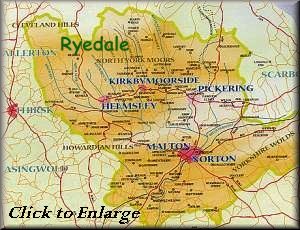
Maps of Ryedale
|
The definition of this map
is limited to download speeds so we hope you can make enough out from
them to be of some use. Thank to Room for Design and Ryedale District Council for the use of the maps |
Getting around in Ryedale
![]() This page is part of
Ryedale.Co.Uk
This page is part of
Ryedale.Co.Uk
Site Administrator for Ryedale.Co.UK, and
E-Mail to :David
Wakeley